Mine Plan Update
On Dec. 18, Twin Metals Minnesota, the wholly owned subsidiary of Chilean mining giant Antofagasta, submitted its plans to open a sulfide-ore copper mine on the edge of - and in the watershed of - the Boundary Waters Canoe Area Wilderness. This begins the slow, methodical march towards acquiring permits that will spell destruction for America’s most visited Wilderness. Here’s some information you need about the mine plan.
1. What is a “mine plan”?
A “mine plan of operation” is a combination of maps and information that describes every aspect of the proposed mining operation. It shows where the mine shaft and extraction areas will be, where the ore will be processed, how the massive amounts of tailings will be permanently stored, where electricity will come from, what new roads and rail lines will have to be created, and what kind of chemicals will be needed to extract the minerals. The full plan that was submitted to the Minnesota Department of Natural Resources (DNR) by Twin Metals Minnesota is here.
2. What's in this mine plan?
There is a ton of information in here, but here is some summary information:
-
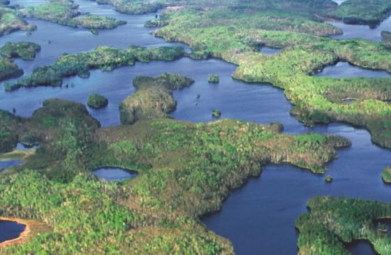
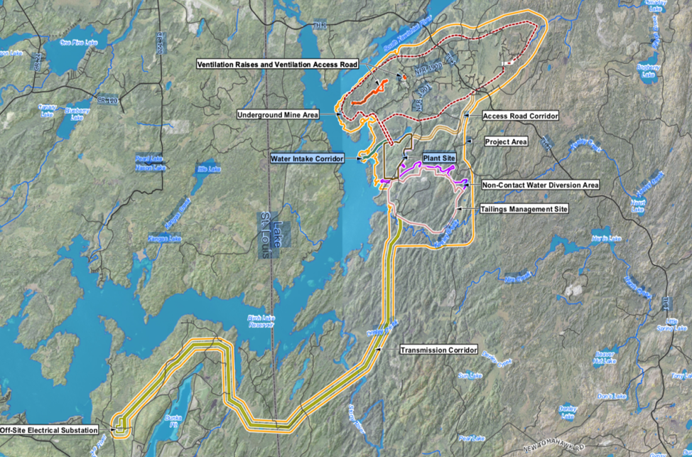
Location (see map appended): directly adjacent the South Kawishiwi River and Birch Lake, about 10 miles southeast of Ely and 10 miles northeast of Babbit. The project area comes within 3 miles of the Boundary Waters Canoe Area Wilderness (BWCAW), and all water from the project site flows into the BWCAW. The mine project area is currently forest and forested wetlands, with small streams flowing through.
-
Size: 1156 acres - almost 2 square miles - of existing national forest will be cleared, filled, graded and converted to an industrial mine site. Within this, a tailings management site will cover 653 acres and the tailings stack itself will cover 429 acres. 156 acres of wetlands will be filled or drained.
-
Dry stack tailings facility: the stack will be comprised of a silty-sandy mixture - abundant in potential pollutants - and will be 130 feet tall. The stack will be built up over time, with dump trucks and bulldozers running almost continuously to manage the material. It will be permanently located at the site. Given the flat topography in the area, and the proximity to Birch Lake, it will be visible for miles. Prevailing winds will carry “fugitive dust” that is loaded with pollutants and will get carried into the BW. The potential amount of seepage is “not known”, but it clearly will end up in Birch Lake and the BW.
-
Water: the project will require up to 130 million gallons of water per year from Birch Lake. That's the equivalent to 200 olympic sized swimming pools worth of water. While Twin Metals says there will be no “process water” discharge, the project requires several holding ponds to manage process water and inflows from precipitation. These are located, in some instances, within 350 feet of Birch Lake and on the most permeable and deep soils in the area. Current drainage in the area will be funneled into ditches, and rerouted around the project site. Some 40% of Birch Lake shoreline contains wild rice that is sensitive to sulfides and other pollutants.
-
Processing facility: several buildings will be constructed on site including an explosives storage building, propane and fuel storage buildings, a 100’ tall coarse ore stockpile dome and the concentrator facility. Most crushing will be done underground, but final concentration crushing will be above ground. There will be 68 vehicles (mostly diesel) working underground, 37 pieces of heavy equipment (mostly diesel) operating at the tailing site, and another 22 vehicles at the processing facility. All of those emissions will be discharged on site.
-
Air: 2 very large (e.g., 17’ by 20’ diameter) tunnels will be constructed to vent contaminated air from the mine into the forest on site. The exhaust will include fumes from heavy equipment (68 dozers, loaders, etc.), blasting, dust from materials handling, carbon monoxide from propane heaters, and other noxious gases, and be blown from the mine with giant, industrial fans. Dust will be generated above ground from handling of ore, from vehicle traffic accessing and on the site, and from the huge tailings facility (as above, 130’ tall, 430 acres in size, comprised of silty sand). Prevailing winds will carry pollutants long distances, including into adjacent waters and the BW.
-
Other: a new, 10 mile long by 150 foot wide corridor will be cut through the forest towards Babbitt, and an electricity transmission line will be constructed. Some 100 heavy trucks per day (including up to 80 tractor-trailers) will enter and leave the site via MN Hwy 1; most will route through Ely.
3. How will this impact the Boundary Waters?
There is no way this project won’t negatively affect the BWCAW. The potentially devastating impacts will occur in multiple ways:
-
Water quality. Today, you can drink the water in the BW straight from the lake. Contaminated water will drain from the mine into Birch Lake via stormwater (i.e., overland flow) and groundwater. Contaminants will include: sulfates, heavy metals, processing chemicals, fuel residuals, sediments and acids. Birch Lake and downstream receiving waters in the BW are currently free of these contaminants, and have no ability to buffer their impact. Once in the water, most of these never settle out, so the loading is permanent. State water quality standards actually allow these pollutants to be discharged, because they were not written to protect a place as pristine as the wilderness.
-
Air quality. The mine will directly emit significant air pollution from blasting gases, scores of diesel machines, propane heaters to heat the mine, and huge amounts of dust that will be blown from the tailings pile, processing facilities and travel corridors. Once airborne, these pollutants will find their way into adjacent waters - that are the headwaters for the BW - and directly into the Wilderness on the prevailing winds. Indirectly, the mine will require a huge new source of electricity. The mine plan does not address this, but we expect a mothballed coal-fired electrical plant will be brought back into use by Minnesota Power (a strident mine supporter). This will have a huge additional emission of greenhouse gases in the region.
-
Ecosystem health. The US Forest Service manages the BW as a wilderness - to the maximum extent possible, the ecosystem is intact. That is true, in part, because the surrounding Superior National Forest is mostly intact. But the ecosystem degradation that will result from the mine will also spill into the BW. Aquatic and terrestrial invasive species will be brought in by earthmoving equipment and significantly increased traffic. Destruction of 2 square miles of forest and 10 miles of transmission corridor will allow for non-native plant, animal and invertebrate species to become established and spread into the wilderness. Water quality degradation will result in a cascade effect throughout the aquatic food web, dramatically changing the biota of waterbodies. Even the introduction of constant, low frequency sound by heavy equipment has been shown to affect animals for miles from their source. Expect a much degraded wilderness adjacent to and downstream of the mine.
-
Other impacts. The permanent 130 foot tailings pile will tower over the trees virtually on the shores of Birch Lake. It will be a permanent visual blight visible for miles. Ditto the transmission corridor and the multiple buildings on site. In addition to the heavy vehicles in use on site - moving material and building the tailings pile - the mine will require semi-trucks to move ore concentrate through Ely to Duluth (up to 80 per day). With other heavy service trucks, more than 100 trucks per day will be routed through Ely. The mine will require up to 130 million gallons per year of water to be withdrawn from Birch Lake, and a new pipeline to supply it. Nighttime lighting and significant vehicle noise will permeate the area.
4. What's next?
The federal government agencies (Bureau of Land Management and US Forest Service) will follow a different - but similar - path than the state agencies (DNR and MPCA). Both governments will spend some time reviewing the many pages of documents to identify if any important material is missing (like the draft reports from the Withdrawal Study!). Then, both will independently announce the beginning of the environmental review process. This will likely be initiated by the federal agencies in January or February, somewhat later for the state agencies. The announcements will also specify when public comments can be provided. This is an important step called “scoping” that is used to decide all the issue areas that must be investigated in the environmental review process.
Federal agencies are under a directive to complete environmental reviews in 1 year and constrained to 150 pages. This is wholly inadequate, and a good indication that the federal government is going to do everything in its power to ram this project through the process. We believe the state rules allow for the MN DNR to hold off on moving the application forward until they have the preliminary reports from the federal withdrawal study. Once they have all the information required by law, they’d start the environmental review process.
5. What are we doing to stop this mine?
Right now, we are actively reviewing the mine plan with the help of several experts. We need to identify all the negative impacts so we can demonstrate to decision makers that this project should not proceed.
We have encouraged the state DNR to stop the process from moving forward by demanding the mineral withdrawal study reports from the federal government (Forest Service). The federal government is hiding these reports and has ignored requests by Congress to release them. We believe the reason is that the reports show clearly that the mine should not be constructed here (why else would the reports be suppressed?). The state DNR should not begin the review process until these important documents are provided. If, as expected, the federal government study has already concluded the project should not be built, why should the state allow it to move forward?
We are also working with our Congressional delegation in Washington, D.C., and especially with Rep. Betty McCollum - a true wilderness champion. She has worked hard to get the hidden withdrawal study released, but the administration is stonewalling. We will continue to work with her to find a way to stop the project. In addition to the above work with the state, we are developing a strategy to get better state standards that would protect the Boundary Waters (more on this as the Legislative session starts in February).
Our lawsuit challenging the federal leases continues in Washington, DC, and we expect a decision in early 2020. If we don’t prevail in the District Court, we intend to appeal to the Appeals Court. Finally, we continue to build our supporter base - and your financial support is critical to our success! - and push hard to get the word out on the mine and it’s devastating impact. We had a great year for media in 2019, and hope to be even more successful in 2020.
6. How do I engage?
Stay informed and stay active!
This project can be stopped if enough people make our federal and state leaders understand this is devastating for the BWCAW and not in the best interests of the state or nation. Calls and letters to elected officials - like Senators Klobuchar and Smith and Governor Walz - are critical and impactful. Letters to editors in your local newspaper are read by many and make a definite impact. Supporting our efforts with your donations and volunteer time is essential - we can’t do this without you. And most importantly, stay informed. We’ll try to keep you updated on this website and through social media about what’s happening. New developments happen fairly frequently, and there are time-sensitive events that require a short turnaround for action. Make sure you get our emails and action alerts, and check back to the website for periodic updates.
Thank you for your support of America’s most popular Wilderness!
Map of the proposed sulfide-ore copper mine.